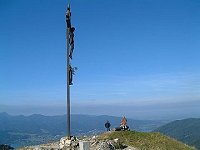
|
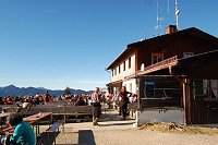
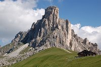
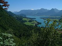
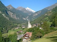
Rotbachlspite (Zillertal, Austria/Italiy)
"Transalp: to Italy on foot" fastinated me. The
route to the Italian border was very easy and is
suitable also for children. Pfitscherjochhaus
with Restaurant is just after the border. From
there the mountain route to Rotbachlsptze
starts. The route is not difficult and is well
indicated. However, the last piece is very
steep. The panorama view from the peak,
especially to the highest Hochfeiler (3510m) is
very nice.
Altitude difference: 1112m
Schlegeis Stausee (1785m) -> Pfitscherjoch
(2238m, 2h)
Pfitscherjoch -> Rotbachspitze (2897m, 1,5h)
Rotbachspitze -> Schlegeis Stausee (2h40min)
Difficulty: Easy to Middle
|
|
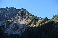
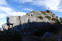
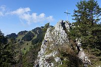
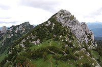
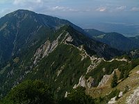
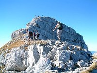
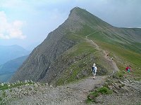
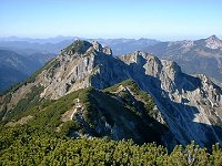
Aiplspitz North
Ridge (Geitau, Germany)
Aiplspitz is known to me from its easy south and
west approach. The sharp and steep north ridge
was tried out.
The route is not so difficult and is maintained
and indicated well. There are only few exposed
points but the route should be avoided under wet
condition.
For going down I took the easier route bound to
Spitzingsattel via Tanzeck and Sch�nfeld-Alm.
Altitude difference: 989m
Geitau-station (770m) ->
Aiplspitz
(1759m
2h)
Aiplspitz -> Spitzingsattel
(1127m, 1h50min)
Difficulty:
Middle to difficult
|
|
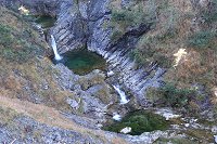
Pfanngraben
(Spitzingsee, Germany)
A hidden quiet route to Rotwand (or
Auerspitz) Pfanngraben is especially recommended
for the early morning before the first bus
operation to Valepp.
The approach route is closed for car traffics
and we have to go down around 3km to the canyon.
The route is going along the beautiful stream
Pfanngraben with many waterfalls.
Altitude difference: 934m
Spitzngsee Kirche (1086m) -> Weitzinger-Alm
branch (950m) -> Rotwand (1884m 3h)
Rotwand -> Spitzingsee Kirche (1h20min)
Difficulty: Easy
|
|
Rabenkopf
(Jachenau, Germany)
Rabenkopf has very attractive approach route
along streams and many waterfalls. This time we
took the route along the Rappinschlucht a very
deet canyon.
Rappinschlucht (canyon) has many stepped
waterfalls that seems very attractive for
canyoning.
In spite of its easy route, the access to the
peak requires very long approach and
corresponding time has to be calculated.
Altitude difference: 787m
Jachenau (768m) -> Rabenkopf (1555m 3h40min)
Rabenkopf -> Jachenau (2h25min)
Difficulty: Easy
|
|
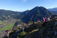
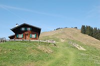
Wallberg
(Rottach, Germany)
It is a good idea to visit a mountain with
rope way during its maintenance period. The
chance came up at a foggy weekend in late
autumn. Such weather promises that the mountain
area has shun shine.
The route has no difficulties as it is also
possible with mountain bike. The only last part
(from the end station of the rope way to the
peak) is only for hikers.
Altitude difference: 947m
Wallbergbahn bus stop
(775m) -> Wallberg (1722m, 1h55)
Wallberg ->
Wallbergbahn bus stop (1h40min)
-> Rottach Post (740m,
22min)
Difficulty: Easy
|
|
Auracher-K�pferl
(Aurach, Germany)
Auracherk�pferl, a not well-known peak of
Aurach, is not a panorama mountain. Since almost
all mountains in this area have been already
checked out, such hidden mountains sound more
attractive now.
Two different approaches are available. Today I
took the easier one from the north side.
Altitude difference: 461m
Fischbachau station (770m) ->
Auracherk�pferl(1231m, 1h40min)
Auracherk�pferl -> Ruin Hohenwaldeck (986m
1h10min)
Ruin Hohenwaldeck -> Fischhausen-Neuhaus
station (800m, 25 min)
Difficulty: Easy
|
|
Kofel (Oberammergau,
Germany)
The symbol mountain of Oberammergau, famous
with its passion play for every 10-Year, seems
extremely steep when it is looked from
Oberammergau.
However, the route from the col behind the peak
is not difficult at all. Only the last part with
steel wires needs careful steps.
Altitude difference: 500m
Oberammergau Cemetery (842m) -> Kolbensattel
(col) -> Kofel (1342m 1h30min)
Kofel -> Kolbensattel -> Kolben-Alm
(1000m) -> Oberammergau (2h10min)
Difficulty: Easy
|
|
Grassleienkopf
(Lenggries, Germany)
Grassleitenkopf is
also a not well-kown peak of Lenggries. This
hidden small peak is located just behind the
Lenggrieser hut. The route continues to the west
narrow ridge and from another peak Grassleiten a
great panorama over Isar is "must be seen".
Altitude difference: 734m
Lenggries Hohenburg (770m) -> Lenggrieser hut
(1338m) -> Grassleiten (11434m 2h)
Grassleitenkopf -> Grassleiten (1296m) ->
Lenggries Hohenburg (1h40min)
Difficulty: Easy |
|
Waxenstein
(Lenggries, Germany)
As a tour just can be terminated before noon
Waxenstein in Lenggries was selected.
From the parking for ski lift it along the jeep
way to Kot-Alm, turn the right at the entrance
of the Kot-Alm, then again to right soon into
the path in the forest. Yellow paint markings
are on trees along the path. The last rock part
is steep and unsecured.
Parking Draxlhang (720m) -> Kot-Alm (1180m,
1h) -> Waxenstein (1310m, 0.5h) 1.5h in total
Waxenstein (1310m) -> Kot-Alm (1180m, 15min)
-> Parking Draxlhang (720m, 45min) 1h in
total
Difficulty: Easy (Last 20m is steep and
unsecured)
|
|
Hunds-Alm Ice
Cave (Lake Thiersee, Austria)
Just thought a light hiking for visiting an ice
cave which has still ice in summer. After
visiting the ice cave which was not enough walk,
we decided to make an optional tour through the
Adler Weg, but it was too much enough with many
peaks and up and down. The cave tour is guided
one including the winter jacket and helmet.
Parking in the forest road above Hinterthiersee
(1045m) -> Hundsalm Ice Cave (1515m, 2.0h)
Ice Cave (1515m) -> Adler Weg ->
H�hlensteinhaus (1233m, 3.5h) -> Parking
(1045m, 1.0h)
Difficulty: Easy (but for the round tour through
Adler Weg requires much time and effort.)
|
|
Setzberg
(Rottach-Egern, Germany)
Setzberg is the neighbour hill of the famous
Wallberg with ropeway.
Starting from the right side of the ropeway
station at the foot of Wallberg, we go up along
the forest street to the flat mesa used as
summer farm. From the mesa you already see the
peak of Setzberg. The last part has almost no
shade and is suitable for tour in late autumn.
Ropeway station (774m) -> Wallberghaus
(1500m, 1h20min) -> Setzberg (1706m, 20min).
Setzberg (1706m) -> Ropeway Station (774m,
1.5h)
Difficulty: Easy
|
|
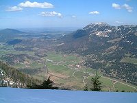
Neureut
(Tegernsee, Germany)
What a beautiful autumn we have in this
year! On mountains it is still comfortable warm,
while in the flat land it is always foggy.
The tables of the Neureut-hut, climbing up
directly from the station Tegernsee, became soon
full in a shourt time.
Today we made a round tour checking some peaks
out enjoying the last sun shine. In addition we
made a long break in the Tegernseer brewery
restaurant.
Tegernsee (760m) -> Neureut (1263m, 1h5min).
Neureut (1263m) -> Gindelalmschneid (1331m)
-> Kreuzbergalm (1223m) -> Baumgarten-Alm
(1363m) -> Riedenstein (1207m) -> Galaun
(1070m) -> Schwaighof (860m) ->
Tegernseebr�u (730m) 4.5h in total.
Difficulty: Easy
|
|
Lacherspitz
(Bayrischzell, Germany)
Because of the ropeway installed for the
neighbour mountain Wendelstein, surrounding
mountains are rather crowded. However, on a late
sunny autumn day such route throughout at the
south side is attractive. The narrow peak was
really full, occupied mostly by our nine
members.
Osterhofen station (806m) -> Hochkreut-Alm
(980m, 30min) -> Siegel-Alm (1330m, 45min)
-> Lacherspitz (1724m, 1h10min) 2h25min in
total
Lacherspitz (1724m) -> Hochkreut-Alm (980m,
1h20min) -> Bayrischzell station (804m,
30min) 1h50min in total
Difficulty: Easy
|
|
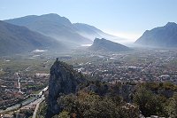
Monte Colodri
(Arco, Italy)
The middle old town Arco is around 6km far in
north from the resort town Riva del Garda. There
is a via ferrata for beginners with 250m height
out of 350m route to Monte Colodri. The view of
the lake garda from the peak is perfect and the
route down to Arco on the west side along the
olive plants is also attractive.
Arco (85m) -> Monte Colodri (400m, 1h50min)
including via ferrata
Monte Colodri (400m) -> Crco (1h10min)
Difficulty: Easy via ferrata
|
|
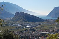
Monte Brione
(Riva del Garda, Italy)
A small hill in the crescent figure at the
east side of Riva del Garda has an antenna on
the top. The east side has very steep cliff
while the west side has gentle slope of olive
plants. Some ruins of batteries installed by
Austrian during the World War 1 are still
existing. This might be a half day light tour
following the history.
Riva del Garda (65m) -> Monte Brione (374m,
1h25min)
Monte Brione (374m) -> Riva del Garda (65m,
2h15min) with round tour
Difficulty: Easy
|
|
Nuvolau (Cortina
d'Ampezzo, Italy)
Nuvolau from the pass Giau about 30 minutes
by car from Cortina d'Ammpezzo in the west, has
a via ferrata for beginners and Averau hut on
the top.
Many edelweiss are found during the tour.
Passo Giau (2236m) -> via ferrata (2350m,
1.5h) -> via ferrata top (2500m, 30min) ->
Nuvolau (2500m, 45min) 2h45min in total
Nuvolau (2500m) -> Passo Giau (2236m, 1.5h)
Difficulty: Easy as via ferrata
|
|
Achsel K�pfe
(Lenggries Germany)
Achselk�pfe are some rocky peaks neighbouring
the Benediktenwand, the northern end of the
German pre-Alpen located between the rivers
Loisach and Isar. Hiking up from Lenggries at
the Isar, we went down by the Brauneck cabin.
Brauneck Parking (710m) -> Achselk�pfe
(1709m, 4h)
Achselk�pfe -> Brauneck Mountain Station
(1497m, 2h)
Difficulty: Middle
|
|
Stolzenberg
(Spitzingsee, Germany)
A quiet mountain Stolzenberg despite of its
easy reach from Munich. The top of this mountain
is not easy to tell and mostly covered by trees
for looking through the sight between the tree
gaps. The neighbouring peek Rotkopf was also
quiet but Ro�kopf was full of audience for the
great panorama.
Spitzingsee (1090m) -> Stolzenberg (1609m,
1.5h) -> Ro�kopf (1580m, 1h) -> St�mpling
(1506m, 30min) -> Spitzingsee (1090m,
1h25min) 4h25min in total
Difficuty: Easy
|
|
Bodenschneid
(Fischhausen-Neuhaus, Germany)
Bodenschneid hidden behind the lake
Schliersee can be reached in 2 hours from the
station Fischhausen-Neuhaus.
The steep path from the Bodenschneidhaus hut
becomes uncomfortable when it is wet, however
this will be ok in such a day afer long sunny
period. The view on the Lake Tegernsee from the
peak is perfect. The other route on the ski area
is taken for the return route.
Fischhausen-Neuhaus (800m) -> Bodenschneid
(1669m, 2h05min)
Bodenschneid (1669m) ->
Fischhausen-Neuhaus via ski area (800m, 2h15min)
Difficulty: Easy
|
|
Ettaler
Manndl (Ettal, Germany)
Ettal a small town with a large monastery is
found on the way from Loisach valley for
Germisch or Mittenwald to Oberammergau. Just
behind the monastery Etterler Manndl stands with
rocky top. The peak area has very steep rock but
secured by thick chain so that everyone can
climb along.
Ettal (877m) -> rock (1530m, 1h45min) ->
Ettaler Manndl (1633m, 15min) 2h in total
Ettaler Manndl -> Oberammergau (837m,
2h30min)
Difficulty: Middle
|
|
Schinderkar
(Valepp, Germany)
This mountain at the border between Germany
and Austria was once done in the clock-wise
direction. This time we will try the other way
round in ccw direction climbing on the
Kar=cirque.
The upper par of the cirque has very crunchy
stones so that is is almost possible to grip
them.
Valepp parking (895m) -> am Tor (1660m,
2h15min) -> Schinder (1808m, 0.5h) 2h45min in
total
Schinder -> Valepp via Trausnitz-Alm (895m,
2h35min)
Difficulty: Middle
|
|
Wildalpjoch
(Bayrischzell/Germany)
Wildalpjoch stands north side of a Sudelfeld ski
area and is a east neighbor of TV-mount
Wendelstein.
This small mountain is suitable for a season
start and has only sunny side.
Bayrischzell Station (803m) -> Wildalpjoch
(1720m, 2h25min)
Wildalpjoch (1720m, 12:00) -> Bayrischzell
(803m, 2h30min)
Difficulty: Easy
|
|
Biglen
(Berneroberland, Switzerland)
On such day with a nice weather, the famous
hiking ways are full of tourists from Japan.
Today we tried an unknown place Biglen, a hidden
quiet hiking route but with wonderful view of
Mountains. Biglen is located at the river that
gathers water from Eigergletscher and forwards
it to Tr�mmelbach fall.
Alpiglen (1616m) -> Kleine Scheidegg (2061m,
1h50min) -> Cross point with the route from
Eigergletscher (2000m, 30min) -> Biglen
(1735m, 1h45) -> Almend (1479m, 1h35min)
Difficulty: Easy
|
|
B�regg (Berneroberland, Switzerland)
There was a restaurant hut on Stieregg hidden by
B�regg and was not visible from Grindelwald.
This quiet restarurant was swallowd by landslip
in 2005. They built a new hut on B�regg just
next to Stieregg.
In 2006 there was another rock fall on the other
side at Eiger east side. These both activities
were caused by schrinking galcier obviously.
Grindelwald (1035m) -> B�regg (1700m 2h50min)
-> Pfingstegg (1390m 1.5h)
Difficulty: Easy
|
|
Ahornspitze
(Mayrhofen, Tirol, Austria)
Ahornspitze near Myrhofen in Ziller-Valley is
rather easy to climb in spite of its almost
3000m height. The Ahornbahn brings us to almost
2000m height. Additionally Edel hut in the
middle of the way provides us with a comfortable
rest point. But be careful, the last several
hundred meters are really steep, breakable and
unstable rocks!
Filzenalm (1955m) -> Edel hut (2238m 70 min)
-> Ahornspitze (2973m, 3h) (Uphill
3h15min)
Ahornspitze (2973m) -> Edel hut (2238m,
1h25min) -> Filzenalm (1955m, 1h10min)
(Downhill 2h25min)
Difficulty: Middle
|
|
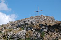
Torscharte
(Hinterriss, Tirol, Austria)
Torscharte is an ideal view point of the East
Karwendel. Somehow I thought Karwendel was very
far from my reach, but today it seemed that I
could touch with my hands! Today I tried to
follow the route in the clock wise direction.
Hinterriss (885m) -> Torscharte (1815m)
(Uphill 2h40min)
Torscharte (1815m, 13:00) -> Hinterriss
(928m) (Downhill 2h)
Difficulty: Easy
|
|
Hineters
Sonnwendjoch (Tirol, Austria)
A very large mountain near the border between
Germany and Tirol in Austria. Despite of its
height almost 2000m, its south face is used as
farm because of its gentle slope, while its
north face refuses any approach. Today I took
the easiest way utilizing a toll road to Ankern
farm in the middle of the mountain.
Ackern-Alm (1383m) -> B�renband-Alm
Branch�@(1580m) 50min -> Hinteres
Sonnwendjoch (1986m) 1h (Uphill 1h50min)
Hinteres Sonnwendjoch (1986m) -> Ackern-Alm
(1383m) 1.5h (Downhill 1h30min)
Difficulty: Very easy
|
|
Vorderskopf
(Hinterriss, Austria)
Vorderskopf located at the border between
Germany and Austria, also the entrance of the
Karwendel has a very remarkable peak. It has a
very flat and wide peak like a football field,
while other mountains in this area have normally
very sharp peaks.
Bus stop Kaierh�tte (885m) -> Jagth�tte
(1526m) 2h -> Vorderskopf (1858m) 50min
(uphill 2h50min)
Vorderskopf (1858m, 12:30) -> Hinterriss
(928m, 15:20) (Downhill 2h50min)
Difficulty: Easy
|
|
Schafreuter
(Vorder-/Hinterriss, Germany, Austira)
Schafreuter located at the entrance of the
Karwendel, which is often pronounced as
"Shafraiter" according to the local way, has one
of the most attractive one-day touring route and
is well known with its T�lzer hut.
Busstop Einstieg - T�lzerh�tte (892m) ->
T�lzerh�tte (1835m) 2h -> Schafreuter (2101m)
45min (uphill 2h45min)
Schafreuter (2101m) -> Moosenalm (1590m)
1h10min -> Oswaldh�tte (847m) 1h20min
�iDownhill 2h30min�j
Difficulty: Middle
|
|
Rechelkopf (Bad T�lz,
Gai�ach, Germany)
Rechelkopf is
the house mountain of Gai�ach south neighbor
of Bad T�lz. Gai�ach is also known with its
cray sled�@racing "Schnablerrennen", in which
many injured have to be treated by doctor.
However, this small hill offers 360-degree
panorama from its peak.
Gai�ach
station (660m) -> Schwaiger-Alm (1123m)
1h15min -> Rechelkopf (1330m) 50min
Rechelkopf -> Greiling (699m) 1h30min ->
Reichersbeuern (718m) 40min
Difficulty: Easy
|
|
Staffel (Jachenau Germany)
The river Jachen is flowing through the village.
Although Staffel is not a well known mountain,
it has an amazing panorama view on the Karwendel
mountain group. The altitude difference is only
722 m so that it is suitable for a half day
hiking.
Jachenau-Point (760m) -> Staffel (1532m)
1h45min
Staffel -> Jachnau Niggeln (745m) 1h10min,
Niggeln -> Point 35min
Difficulty: Easy
|
|
Zwieselberg (Bad
T�lz, Germany)
Zwieselberg is a house mountain of Bad T�lz.
Even it has not a high altitude, I walked around
about 24km distance, because I go there with
train. Zwieselberg is a neighbor mountain of
Blomberg, where lift is operated also in summer.
Therefore many family hikers visit there.
Obergries-Station (666m) -> Zwieselberg
(1348m) 2h15min, Zwieselberg -> Pest-chapel
(710m) 2h, Pest-chapel -> Bad T�lz station
(687m) 1.5h
Difficulty: Easy
|
|
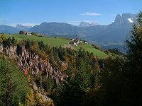
Oberbozen
(Bozen/Bolzano/Italy)
T�rggelen is derived from a Latin word torculum,
which means wine presser. It means also to enjoy
autumn in south Tirol with its harvest products
such as wine, hams and chestnuts on the way of
hiking. This time I visited Oberbozen
(Sorpabolzano) located on the north side hill of
Bozen (Bolzano) to enjoy T�rggelen.
Almost flat hiking routes of 1.5h .. 3h
durations
Difficulty: Easy
|
|
Gr. Traithen: (Bayrischzell/Germany)
Gr.Traithen is the highest peak of the mountain
groups located in the east side of Bayrischzell
village, about 60km far from Munich. Every guide
book says that the way to the peak from Fell-Alm
is very slippery.
Let's see how slippery it is!
Rosengasse Parking (1033m) ->
Gr.Traithen (1851m) (2h40min)
Gr.Traithen (1851m) -> 1478m point
(1h50min)
1478m point -> Rosengasse Parking (1033m)
(1h30min)
Difficulty: Easy
|
|
Blauberge:
(Wildbad Kreuth/Germany)
Blauberge is located in the south direction from
Tegernsee lake and just on the border to
Austria. It consists of four peaks including the
highest one Halserspitz (1863m). They are
connected by a narrow ridge. The south side
seems to be a gentle farm while the north side
is steep cliff.
Bus stop Siebenh�tten (822m) -> Halserspitz
(1862m)�@(3h50min)
Halserspitz (1862m) -> Wildbad Kreuth
(2h30min)
Difficulty: Middle (Steep climbing from
Wolfsschlucht and going down the norh ridge need
attentions) |
|
Hohe Kisten:
(Eschenlohe/Germany)
Eschenlohe is a beautiful small village at the
Loisach river and nearly at the end of the
freeway 95. Ester mountains are located in the
south direction from Eschenlohe. One of the
attractive and the most easy to climb peak is
Hohe Kisten (1922m).
Parkking Eschenlohe (678m) -> Pustertal
Huter's Haus (1320m) 2h05min -> Hohe Kisten
(1922m) 1h30min
Hohe Kisten -> Pustertal Jagdhaus 2h ->
Parkplatz Eschenlohe 1h30min
Difficulty: Middle (Breakable Double-Kar needs
careful steps.)
|
|
Heimgarten:
(Kochel/Gemany)
Heimgarten and Herzogstand at lake Walchensee
are also popular mountains because of a cabin
rope way. The two mountains are connected by a
narrow edge,. where lake Kochelsee and lake
Walchensee in view. This time we took the round
route in the clock-wise direction.
Parking at the rope way station - >
Heimgarten (1788m) 2h35min - > Herzogstand
Pavillion (1731m) 1h30min - > Parking
at the rope way station 2h
Difficulty: Easy (Some steel ropes and poles are
availabel on the connection edge between
Heimgarten and Herzogstand)
|
|
Schildenstein:
(Wildbad Kreuth/Germany)
Schildenstein located at the west end of
Blauberge has two different characteristics;
a family friendly hiking route from west and a
little climbing from east.
Bus stop Siebenh�tten (822m) -> Wolfsschluft
(984m) 1.5h -> Schildenstein Saddle (1464m)
50min -> Schildenstein (1613m) 30min ->
Klammaufstieg (830m) 2h -> Wildbadkreuth
(793m) 40min
Difficulty: Middle (Steep climbing from
Wolfsschlucht needs attentions)
|
|
Sch�nberg:
(Lenggries/Germany)
Sch�nberg (1620m) is the neighbor mountain of
Seekarkreuz (1601m).
Sch�nberg itself does not provide any challenge,
but the way to Seekarkreuz seems to be much more
interesting.
Fleck (735m) -> R�hrelmoos-Alm (1100m)
1h40min -> Sch�nberg (1620m) 1h50min ->
Mariaeck (1469m) 20min -> Lenggrieser hut
(1338m) 1h -> Fleck 1h30min
Difficulty: Middle (Passage from Mairaeck to
Seekar needs attentions)
|
|
Seekarkreuz:
(Lenggries/Germany)
Seekarkreuz (1601m) is a gentle mountain for
family hiking located near of Lenggries. The
tour includes further 3 peaks; Spitzkamp,
Auerkamp and Ochsenkamp. Lenggrieser hut shortly
under the peak of Seekarkreuz is also worth to
visit.
Lenggries (679m) -> Lenggrieser Huette
(1333m) 2h -> Seekarkreuz (1601m) 30min ->
Spitzkamp (1603m) 35min -> Auerkamp (1607m )
20min -> Ochsenkamp (1594m) 15min ->
Hirschsattel (1224m) 35min -> Lenggries
1h30min
Difficulty: Middle (South face of Spitzkamp is
very steep)
|
|
Tuxer-Joch:
(Hintertux/Trio Austria)
Hintertux is a famous village in Tirol with its
glacier for summer skiing. It is very beautiful
area not only for skiing but also for hiking.
Thanks to its higher altitude, different scenes
like glacier and vegetation like edelweiss are
expected.
Sommerberg-Alm (cabin station, 2030m) ->
Tuxer-Joch-Haus (2316m) 40min -> Weissjoch
(2518m) 30min -> Tuxer-Joch-Haus 20min ->
Water fall (2020m) 55min -> Sommerberg-Alm
1h25m
Difficulty: Easy
|
|
J�gerkamp: (Spitzingsee/Germany)
One of the most easy and popular mountain
J�gerkamp (1745m) is located at just in front of
the door of Munich.
On such a hot summer day, we took a forest route
at the west shadow of the mountain.
Parking (945m) -> Jaegerbauer-Alm (1544m)
1h20min, Jaegerbauer-Alm -> Jaegerkamp
(1745m) 30min, Jaegerkamp -> Schoenfeld-Aml
(1420m) 40min, Schoenfeldalm -> Spitzingsee
(1084m) 1h10min, Spitzingsee -> Parking via
Sattel(1127m) 40min
Difficulty: Short and easy tour
|
|
Hirschberg:
(Tegernsee/Scharling Germany)
Scharling is located in the south
of Tegernsee.
Hirschberg is one of the most popular mountain
in the Tegernsee area. Its massive body is
recognizable from all over the area. In spite of
its scale, Hirschberg is easy also for family.
Its popularity may be by a mountain hut
Hirschberghaus, which is open through the year
(except for Christmas season).
Scharling(767m) -> Hirschberg(1670m): 3:00,
Hirschberg -> Hirschberghaus -> Scharling:
2.30.
Difficulty: Short and easy tour. |
|
Leonhardstein:
(Tegernsee/Kreuth
Germany)
Kreuth is located in the south of
Tegernsee.
Leonhardstein is like a symbol of Kreuth. This
pyramid mountain is visible from everywhere of
the village Kreuth. Although this mountain is
small, the second half part becomes an
interesting climbing.
1450m,Kreuth (772m) -> Leonhardstein
(1450m):01:30 (tried to go as fast as possible.
Standard time would be about 02:00),
Leonhardstein -> Kreuth: 01:30
Difficulty: Short and easy tour with steep
climbing that children can do (better?). |
|
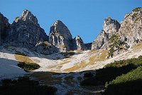
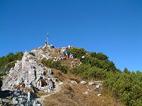
Guffertspitze:
(Achensee/Steinberg
Austria)
Guffertspitze is the highest one in
Achensee valley area. It looks like Matterhorn
sometime from certain view angles. Because it
stands isolated from other mountains, it
provides an incredible panorama view from the
peak.
2195m, Uphill: about 3.5h, Downhill: about 3.0h
Difficulty: Easy tour with a little steep
climbing guided with several steal ropes at the
knife edge near the peak. |
|
Baumgartenschneid:
(Tegernsee/Schliersee
Germany)
Between Teegernsee and Schliersee
was also an open issue. The highest one of this
area is Baumgartenschneid (1448m). Another
panorama point with a small chapel Riederstein
is on the way from Tegernsee station. Some
gentle peaks with lunch huts can be connected,
1826m, Uphill: about 2.1h, Downhill through
several other peaks to Schliersee: about 2.75h
Difficulty: Very easy tour without critical
passage. (The second half is possible also by
moutain bike.). |
|
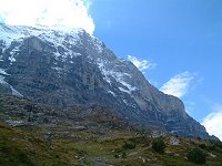
Eigertrail:
(Berner Oberland/Switzerland)
This hiking route just beneath of
the Eiger north face was opened in 1997. You can
see the details of the north face and how great
and crazy the climbers are, who tried and
succeeded or lost to challenge the wall. This
route is closed as long as any danger such as
valance is alarmed. It is recommended to try in
autumn.
2326m, Uphill from Alpiglen to Eigergletscher:
about 2.6h, Downhill to Kleine Scheidegg: about
0.8h
Difficulty: Easy traversing (The route may be
closed when any danger like avalance is
expected.)
|
|
Faulhorn:
(Berner Oberland/Switzerland)
The route from Bussalp(1800m) to
Faulhorn (2680m) was still open. A nice panorama
view to the Berner mountains maks us never being
tired. Tour in high temperature might be to hot,
because whole route is facing to south without
tree. This might be an easy but interesting ski
tour route because of its constant inclination.
1826m, Uphill: about 2.6h, Downhill to Gr.
Scheidegg via First: about 3.25h
Difficulty: Easy with no critical passage.
|
|
Risserkogel:
(Tegernsee/Kreuth Germany)
A hidden highest peak in the south
area of Tegernsee Risserkogel (1826m) showed
almost all the surrounding pre-alpine mountains
and nice view on the Austrian alpine. The
neighboring Blankenstein shows also amazing wild
rock figure.
1826m, Uphill: about 2.4h, Downhill: about 2.2h
Difficulty: Easy with one steep climbing guided
with several steal ropes at the north side of
Risserkogel. |
|
Geigerstein/Fockenstein:
(Lenggries/Bad
Wiessee Germany)
On the east side of Isar river at
Lenggries, 1 hour train trip from Munich,
Geigerstein (1491m) seems to be one of the good
panorama point. The second peak on the way to
lake Tegernsee, another peak Fockenstein (1564m)
was also waiting. This tour is rather long but
is not so hard as expected.
Total altitude difference is about 1200m, Uphill
3.0h, downhill 2.5h. Easy tour with some steep
rock cliff.
|
|
Trainsjoch:
(Ursprung Austria)
Trainsjoch (1708m) is just on the
border between Germany and Austria.
We can go along the border on the edge finding
border stones.
The start point "Ursprung" (830m) means
"origin", that matches exactly to this tour.
878m, Uphill 3.0h, Dowhill with round tour 2:40.
Easy tour with one steep slope at the west
aproach of the top.
|
|
Br�nnstein:
(Oberaudorf Germany)
Br�nnstein (1619m) was also open.
To park at Rosengasse Parking (1060m), at the
east side of Sudelfeld ski area, motorcycle is
easier.
It was hard to decide whether Br�nnstein or Gr.
Traithen to hike up today. Another friendly
group made me a decision to go with them to
Br�nnstein.
559m, Uphill 2.5h, Downhill with round tour
3.0h. Middle difficulty with steep cliffs
equipped with steal wire ropes and other support
materials.
|
|
Ro�stein:
(Bayerwald Germany)
Ro�stein (1698m) and Buchstein (1701m) are
famous with their remarkable hut,
Tegernseerhuette, which is pasted between two
rocks.
It takes only about 45 minutes from munich to
Bayerwald on the foot of these mountains.
This tour has an interesting steep cliff as a
small challenge.
840m, 5:00 easy round tour with a steep cliff
equipped with steal wire rope. |
|
Falkenstein:
(Salzkammergut Austria)
St.Gilgen and St.Wolfgang at
Wolfgangsee in Salzkammergut are connected by a
hiking route. Mountain bikers are also on the
way..
250m, 3:30 easy tour also for children.
|
 |
Mayrhofen:
(Tirol Austria)
Zillertal (Ziller valley) is one of the most
beautiful and attractive area of Tirol in
Austria.
It takes only about 2 hours from Munich.
Everything is inexpensive there in spite of its
very modern infrastructure.
300m, 5:00 easy round tour. |
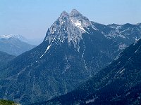 |
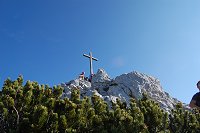
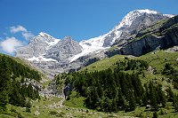
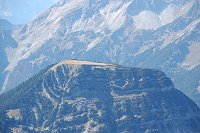
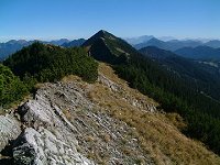
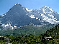
Juifen: (Tirol
Austria)
Only several km from the border of Germany and
Austria, Juifen is standing hidden with other
mountains. Juifen has a rather long reach but
not steep approach, which makes it possible to
bike up or hike up with skis.
The picture is not Juifen but Guffert, almost
Matterhorn of Achen valley.
1100m, Uphill 3:30, downhill 3:00. Easy tour. |
 |
Seeberg:
(Bayrischzell Germany)
It was almost not possible in last year because
of broken trees by a storm.
I just heard from a old lady, whom I met some
times in the train, said that the route is just
opened.
738m, Uphill 2:30, downhill 2:00. Easy round
tour. |
 |
Brecherspitz:
(Fischhausen-Neuhaus Germany)
In autumn once it becomes cold, then again warm.
They call it Altweiber Sommer. This week through
it was very hot really like in summer. On
Saturday the temperature reached almost to 30
degrees.
863m, uphill 1:35, traverse and downhill 2:00.
Easy tour except for a critical point just
underneath the peak of the Brecherspitz. |
 |
Miesing: (Geitau
Germany)
Miesing(1883m) is located in Mangfall group,
which can be said as Munich's house mountain.
1103m, uphill 2:40, downhill 2:30. Easy but
rather long round tour. |
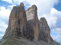 |
Tre Cime di
Lavaredo: (Dolomite Italy)
Is there any other mountain with such a
remarkable figure?
Tre Cime di Lavaredo is not so far from Munich.
I would take about 4 to 5 hours with car or
motorcycle.
This funny mountain is near from Cortina
d'Ampezzo in Italy.
Light up-down in 3:30. Easy round tour. |
 |
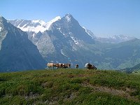
Kleine
Scheidegg: (Berner Oberland, Switzerland)
Grindelwald is one of the most popular area in
Switzerland.
In 2003 we had experienced the hottest summer,
so the hiking course had to be higher than
2000m.
Maenlichen-Kleine Scheidegg 2h light walk
Kleine Scheidegg-Grund 3:00 long downhill. |
 |
Schinigeplatte:
(Berner
Oberland, Switzerland)
Hiking from First to Schinigeplatte is also nice
for summer.
The highest Hotel on the top of Faulhorn is
waiting for us with lunch.
First(2167m) -Faulhorn(2680m) 2:30
Faulhorn-Schinigeplatte(2067m) 3:45, long walk
with no difficulties (before July could be
difficult because of snow). |
 |
Grosse
Scheidegg: (Berner Oberland, Switzerland)
It takes about 30 minutes to Grosse Scheidegg by
bus from Grindelwald.
Today I have to leave to Munich again. This
route is the optimum one for the last tour.
Grosse Scheidegg �i1962���j- First (2167m),
2:00, easy tour. |
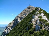 |
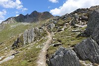
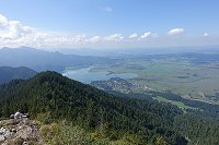
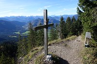
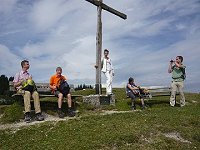
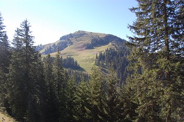
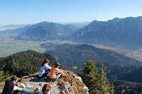
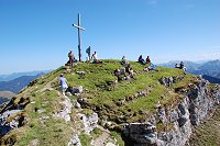
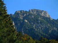
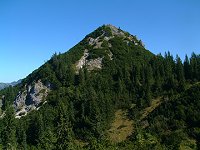
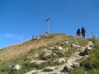
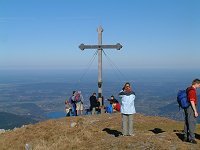
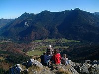
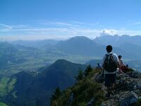
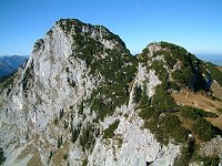
Aiplspitz:
(Geitau, Germany)
A pyramid form mountain is seen from Geitau.
Compare with its north face, the approach from
south is very easy.
Geitau (780m) - 3:00 -Aiplspitz(1756m) -3:15-
Fischhausen-Neuhaus (820m), rather long and
middle difficulty. |
 |
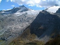
Gr.
Glockner: (Heiligenblut, Austria)
A small hiking with a great view of Pasterze
Glacier and Gr. Glockner starting from
Glocknerhaus down to Margaritzenstausee.
Glocknerhaus(2135m) - Steinzeichen - Pasterze
Glacier - Franz-Josefs-hoehe(2386m) -
Glocknerhaus, about 400m height difference,
3:30, easy round tour. |
 |
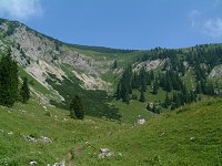
Breitenstein:
(Geitau/Fischbachau, Germany)
Breitenstein is a small mountain at the north
end of Alps.
Geitau(790m) - 2:30 - Breitenstein (1622m) -
2:00 - Geitau.
832m, easy tour. |
 |
Rotwand/Taubenstein:
(Spitzing,
Germany)
One of the most popular mountain for the people
in Munich is Rotwand
Normally cabin rope way (Taubensteinbahn) is
used for a family hiking.
From Spitzingsee it is also easy to reach.
Spitzingsee(1100m) -2:45- Rotwand (1884m) -1:15-
Taubenstein (1692m) - 2:00 - Spitzingsee
780m, easy tour. |
 |
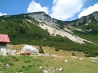
Benediktenwand:
(Lenggries/Benediktbeuren/Jachenau, Germany)
Benediktenwand is located also the north end of
Alps.
Utilizing the Brauneck cabin rope way
(Brauneckbahn), we got additional time for
optional peaks such as Latschenkopf and
Achselkoepfe.
Brauneck Station (1480m) -1:00- Latschenkopf
(1712m) -1:00- Achselkoepfe 2 (1675m) - 1:00 -
Benediktenwand (1800m) - 3:00 - Jachnau (790m),
Total uphill about 900m, middle difficulty. |
 |
Hirschh�rnlkopf:
(Jachenau, germany)
Hirschh�rnlkopf, a difficult to pronounce but
easy to hike up, is just near of Jachenau.
Hiking up along the south face is great for a
sunny winter day.
Jachenau (790m) -2:00- Hirschh�rnlkopf (1514m)
-1:30 - Jachenau
724m, very easy tour. |
 |
Schinder:
(Valepp, Germany/Austria)
Schinder has remarkable "Kar" at the north side.
It looks like a volcanogenic mountain.
A mountain toll road from Rottach-Egern brings
us to Valepp.
Valepp (900m) -2:45- Austria Schinder (1808m)
-2:30 Valepp.
908m
Difficulty: middle |